Place mats – Designing

I am in the process of sewing 1068 small pieces of material together with the goal of making 6 place mats for our kitchen table. I don’t mind the sewing, but my mind needs something to do while my fingers to do the work. So this series of blogs has been written in my mind several times before actually sitting at the computer to do the writing.

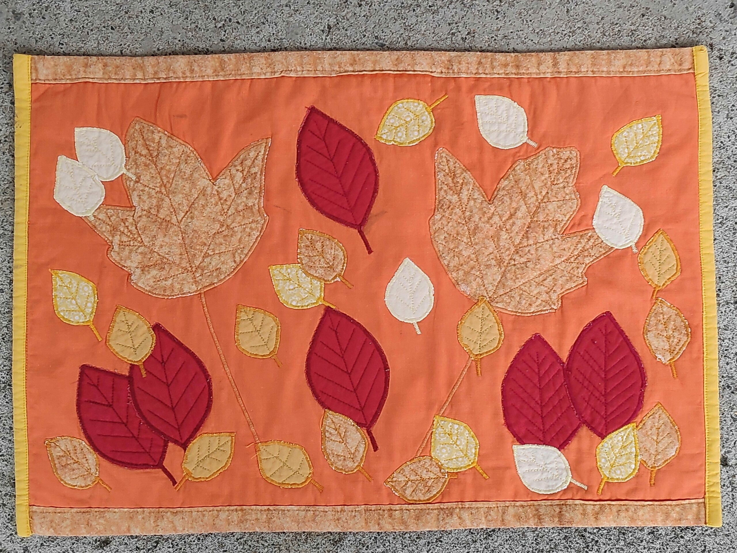
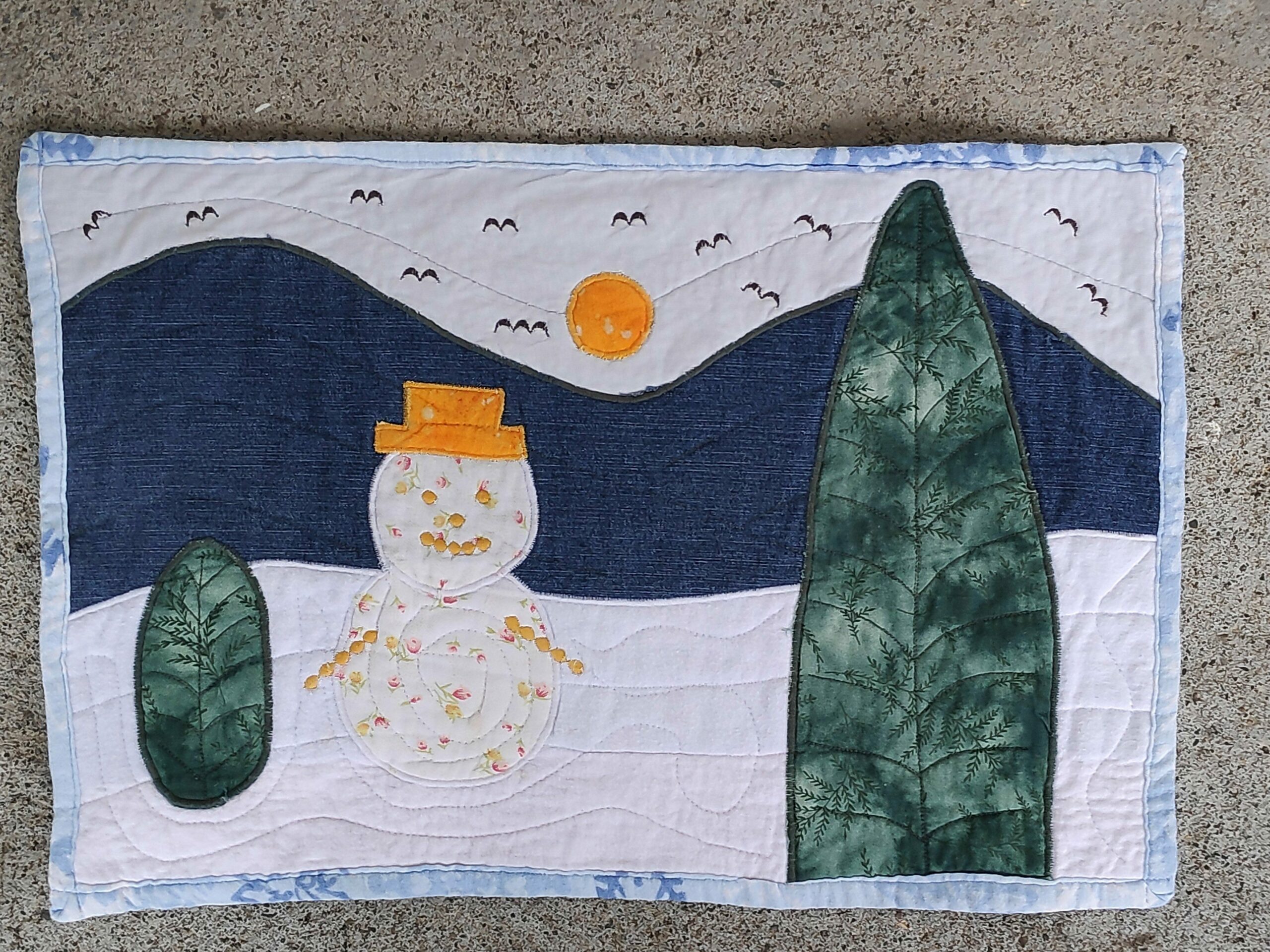
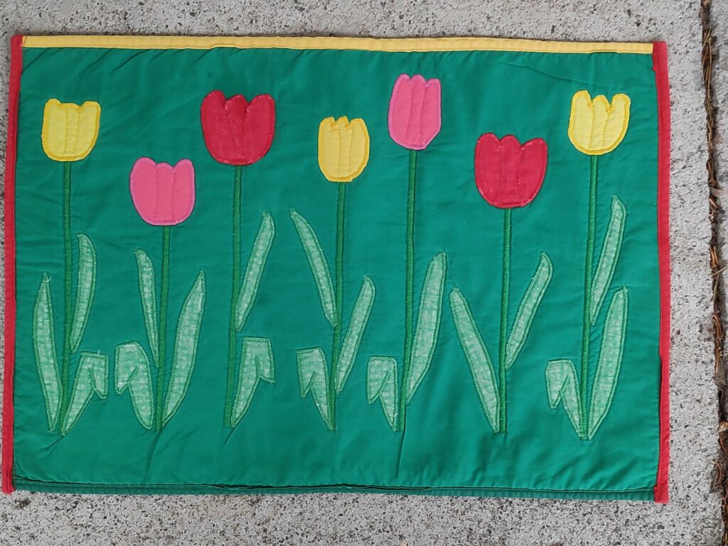
Several years ago I started making a series of place mats using patchwork and quilting techniques. The first series was autumn leaves, the second series was winter and the third series was spring tulips. We use the autumn series and the tulip series regularly, but the winter series I wasn’t that happy with and they have been taken out of active service.

The first set of 4 place mats with a theme of autumn and leaves found in our yard – maple, beech and birch. The placement of the leaves on each place mat are slightly different.
The second set of 4 place mats with a winter theme. Though each place mat has a snowman and two trees, they are all a little bit different.
This time I made a series of six place mats with tulips as a symbol of spring. These usually blossom in May here.

In July 2020, we bought new dishes for the kitchen, a beautiful blue (my favourite colour) from IKEA. However they didn’t look very good on either the orange or the green place mats, so I started thinking about a new set of place mats that went better with the new dishes.

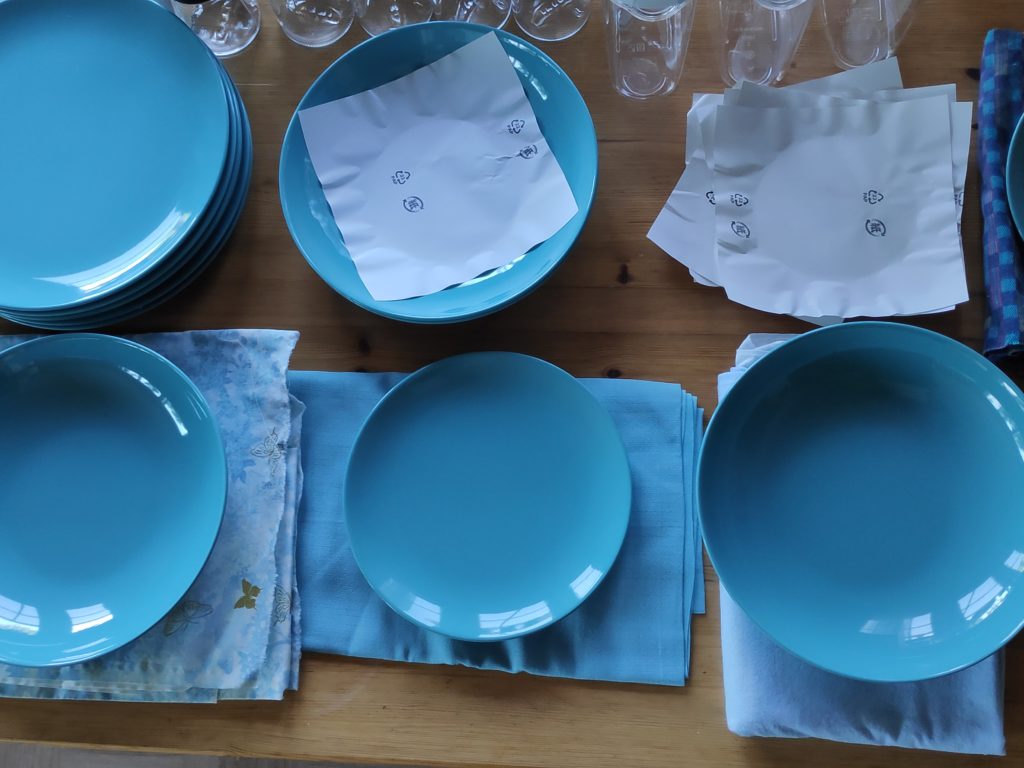
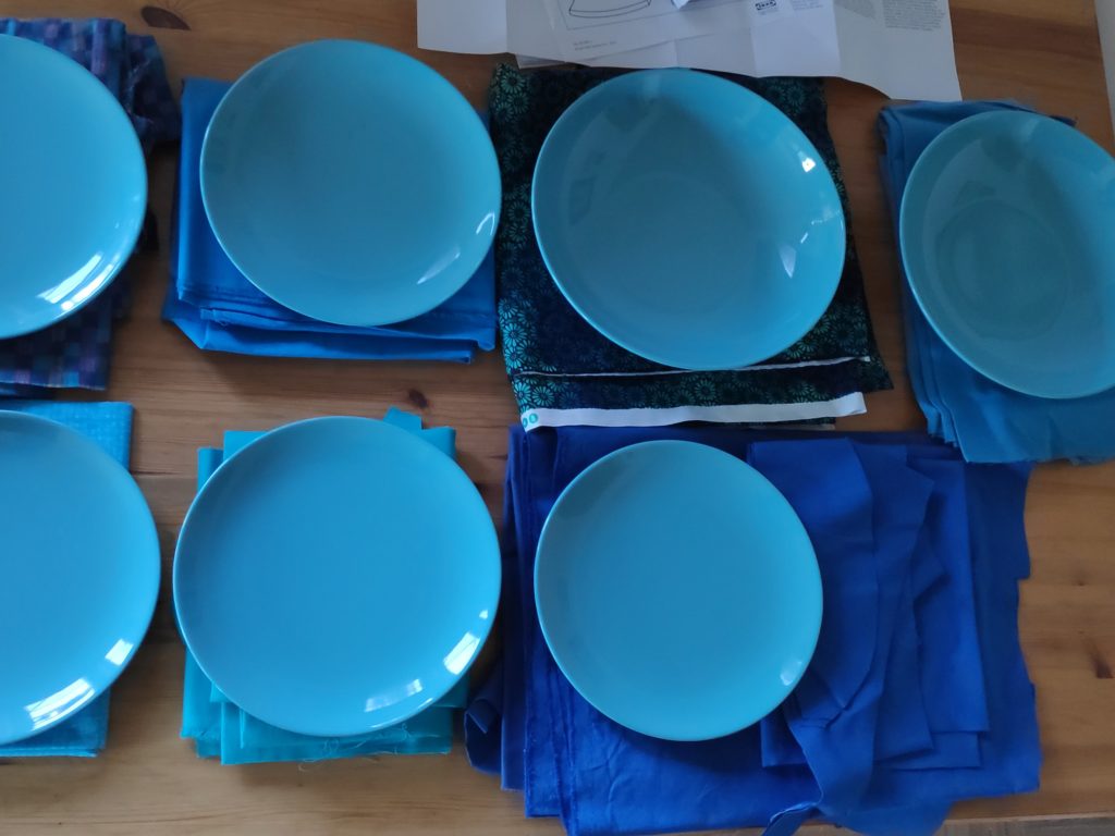
Already the day after I had bought the new dishes, I went hunting through my boxes of leftover material and looked for a variety of materials that went well with the new dishes. I set aside the ones that went well and then the ideas of what to use and how to use the material had to mature for a while.

Eventually I decided on three materials that I would use on the top of the place mat and a plain dark colour for the backside.

The bottom material in the pile in the picture is big enough to make the back side of six place mats. The other three will be used to make a pattern for the top side.

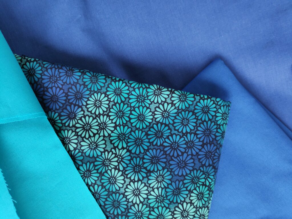
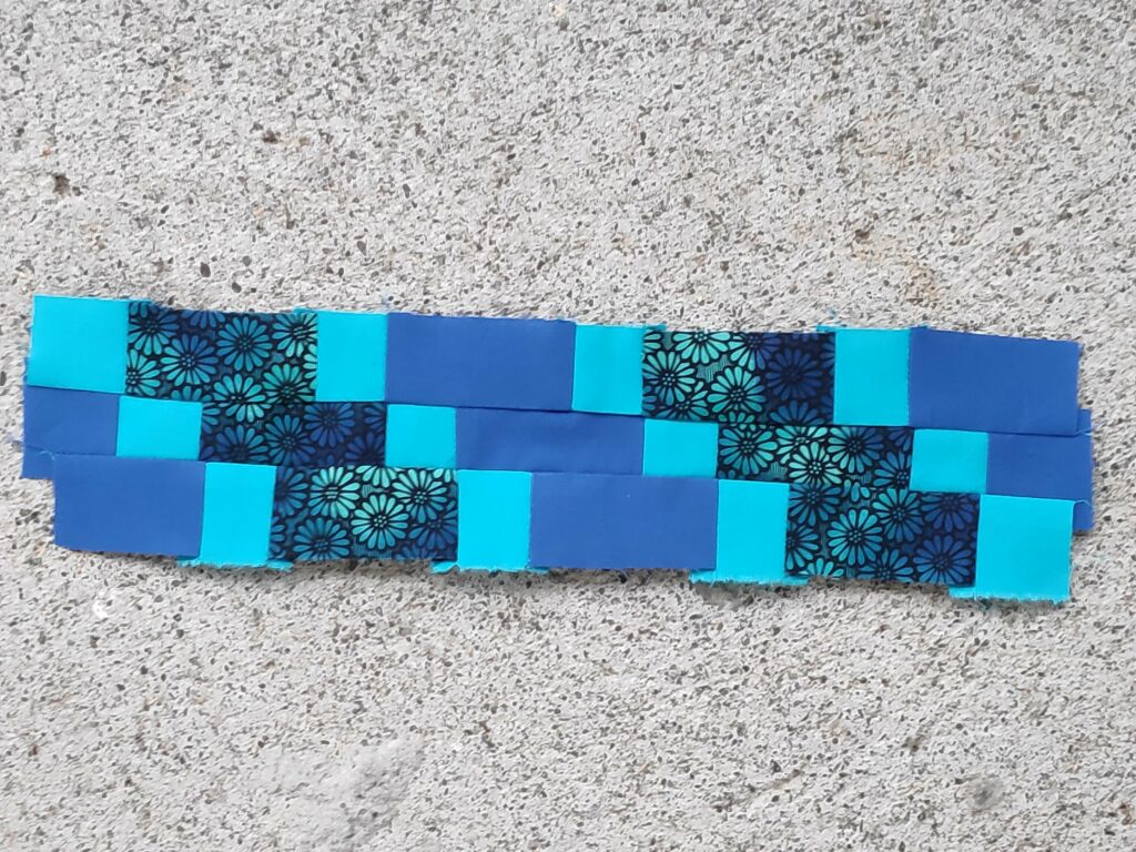
Time goes by and the idea sits there and I have to decide on what sort of pattern to make. I decided something more geometrical this time and decided on a zigzag pattern, using the three chosen materials. The lightest colour is quite bright, so small amounts of it.

I made three suggestions for a zigzag pattern with slightly different proportions. Finished size played a role and I chose the top left-hand pattern to continue with.

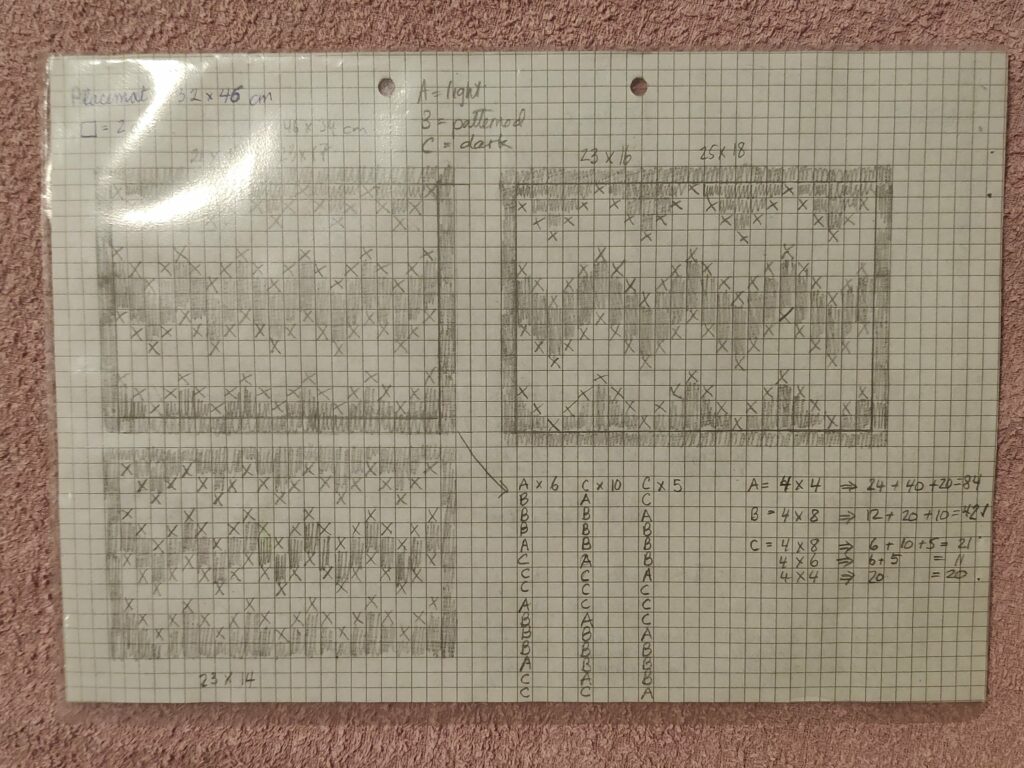
In the bottom right-hand corner I calculated the sequence of the pieces of material. One square on the paper is 2 cm, so three squares means that the finished piece is to be 6 cm long. X and A refer to the light blue material. The shaded squares and C are the dark blue material and the blank squares and B are the patterned material.

This is the sampler I made to make sure that I liked my pattern.
The calculations for how many small pieces to cut.

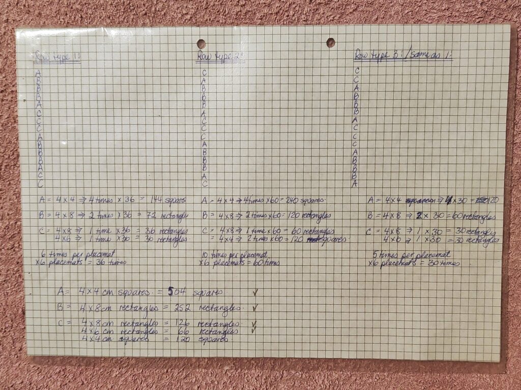
Next came the detailed calculations of what size pieces I would need and exactly how many I would need for 6 place mats. Some are 4 x 4 cm, some are 4 x 6 cm and some are 4 x 8 cm. All pieces have 1 cm on each side for seam allowance, so a 4 x 4 cm square will come out as 2 x 2 cm in the finished place mat. The total came to 1 068 pieces plus a few extra for good luck.

The next blog will be about sewing the pieces together.

Inderøy Walk – Mosviksenderen /Skavlen Transmitter

It is now October and winter weather is around the corner. My friend and I had looked up at the tall mast last week and agreed to walk up to it, if the weather permitted. The weather wasn’t that great, but we did the walk anyway.

I’ve been trying to find information about the mast but the information I have found is a bit limited. The building is located at 401 meters above sea level. The mast is a transmitter for several Norwegian television and radio stations and was built in 1973. (https://en.wikipedia.org/wiki/Skavlen_Transmitter )

The hill in the distance, covered in cloud, is where the mast should be visible on a clear day.

We drove along Fv 192, towards Saltvikhavn in Mosvik, drove about 1.5 km past the turn to Salvikhavn and found a parking spot on the side of the road. After all, we wanted the uphill walk for the exercise. We parked about 2 km from the mast at an elevation of about 200 meters above sea level. The temperature was about 3 degrees Celsius and there had been snow at higher elevations in the night. There was some slush on the road, much of which is a gravel road. Thankfully my friend had already changed to winter tires on her car.

As we started our walk up the hill it was obvious that the views today would be very limited. Cloud cover was low, but there was no precipitation while we were walking. The closest spit of land is Ytterøy, an island. In the distance is Levanger.
The first part of the road leads around a farm. As we walked uphill, the sheep were being moved into a different field. They all seem to have their winter coats on and they had on different colours. The darker ones had horns.
As we walked uphill, there was more and more snow. It was a bit slippery under foot. But we weren’t the first ones up the hill today. We saw one vehicle drive up and there were tracks of several vehicles in the new snow.
I asked my friend what she thought the purpose of the sign was and her comment was that when there is a large amount of snow in the winter, the road needs to be marked. They may not plough the road all winter, but it would have to be usable by snow scooter. There were lots of other trails off the road, often with tracks from an ATV.
“Danger – ice falls from antenna” – we must be getting nearer our goal. Notice how much snow there is now. Height above sea level makes a big difference. At lower elevations the precipitation would be rain. We have now climbed about 200 meters in elevation.
Finally, the goal of our walk, though the top of the mast disappeared into the cloud cover. I was surprised at how large a building was connected to the mast.
There were three vehicles outside the building, doors were open and people were obviously at work. Here is where the cables come out of the building and head up into the mast.
There was certainly a lot of different equipment on the mast and I couldn’t see all the way to the top because of the cloud cover.
I’m not sure if the view would be much more interesting in clear weather. Though one sees the mast in clear weather from afar, standing on the ground at the bottom of it, it looks like there are a lot of trees around it.

Though I enjoyed the walk, I would definitely recommend doing the walk when the weather is clearer. I plan to do the walk again next year, in the summer months of the year. The walk was a little over 2 km each way and we used a little over an hour.

A few days later I was able to take this photo of the mast, taken from the other side of Skarnsund. Though it shows up well for the naked eye, I had problems getting the mast to show up in a picture, even when I zoomed in a lot.

I have zoomed in a lot to take this picture, which means it became very grainy.

Inderøy Walk – Korpåsen in Mosvik

Today was a pleasant autumn day, with no wind or rain. I went for a walk with a friend. We meet most Wednesdays and enjoy walks in various parts of Inderøy.

She parked her car near the school in Mosvik and we walked around the farm called Stor-Grande and were soon in the woods. Though we started off heading towards one particular check-in place, we ended up changing our minds and going to Korpåsen which has a beautiful view. We used about an hour and a half on today’s walk.

A lot of the walk was along a tractor road. It was steady uphill, but not steep.
Though the tractor road was easy to walk along, the terrain went up very steeply and down very steeply on either side of the road. This wasn’t an area to walk off the road.
The tractor road was in good condition and obviously used. We came to an open field where the sun was shining on the trees turning yellow.
We had come from Stor-Grande, a blue trail, meaning that it was easy walking. So far we had walked 2.1 km. To the right in the picture one can see the trail that goes towards Øksnåsen.
In the middle of the woods we came to this sign with a map of the area. We took the trail towards Skarnsundbrua. Now we were on a more difficult walk.
Now the trail became narrower and slightly more challenging, with roots in the path and in places large rocks to climb up. Here you can also see a small wooden bridge across a stream. Note the red and white streamer on the tree on the right which is the modern method of marking trails. On the tree to the left is a round patch of red paint which is the older method of marking trails in the woods.
Somebody has made visitors welcome by putting up a sign telling the visitor what the name of the place is. From here there is a view over Trondheim Fjord and the center of Mosvik.
There was even a flag flying today. The box on the tree has a book one can write one’s name in.
The view looking westwards towards Trondheim.
The view looking eastwards towards Verdal.

Today the temperature was about 9 degrees Celsius, so we didn’t sit long at the top. There was just a bit of a breeze and after climbing uphill we cooled down quite quickly. Soon we were walking again and heading down the hill to the car. It was a very pleasant outing with a good friend. This is a recommended walk, with many variations if one wanted to take an even longer walk. See the map in the picture above for suggestions on a round trip in the area. We walked back down the hill the same way we had gone up.

Inderøy Walk – Steinen in Mosvik

I enjoyed today’s walk in the October weather. There was a bit of a wind, the leaves are turning yellow, gold and red and being blown in the wind. It was cloudy, so not so very bright, but no rain either. Today’s walk took about one hour. My two walking companions today were my husband and my son.

The start of the walk is at Vikavatnet where there is ample parking for cars.
At the parking area there is also a small open hut for seeking shelter from the wind and the rain. Inside was a grill and outside another grill area.
View of Vikavatnet from the picnic area. We then walked to the far end of the lake and up the hill on the other side.
Most of the walk is on a gravel surface and wide enough for three people to walk comfortably. This walk is also advertised as suitable for wheelchairs.
The road climbs gently up on the north side of the lake. Most of the deciduous trees have started to change colour. The dark green trees will be mostly pine or spruce.
The soil here seems to be very poor, as it was mostly moss and lichens and the few trees were pine. Blueberry and similar low plants were turning red.
Eventually we were on a slightly narrower path with muddy bits. We were able to check in to the walk on the app at the end of the road, in consideration for wheelchair users. This trail would eventually go down to an uninhabited farm.
The goal of the walk, post 27, is this outcrop of rock facing onto Verrasundet, here looking westwards toward Trongsundet. As can be seen in the picture, the morning was overcast but the temperature was about 14 degrees Celsius.
Here is where there has been a farm in the past and the trail would continue on down to it. There appear to be some fields that are still in use. I am standing on a steep cliff.
Looking eastwards along Verrasundet, towards Follafoss.
We are on the wrong side, i.e. the south side of the fjord, the north side of the slope, for agriculture. In the background, one can see the row of farms on the other side of the fjord, There the farms would receive adequate sunshine for agriculture. This is very typical of Norwegian fjords that run east to west.

This walk is suitable for anyone. One could park closer to the gravel road than we did, but there were few cars on the asphalted road along the lake. There were no steep climbs and few muddy areas.

Local food

I made a decision a while ago to buy locally produced food when it was conveniently available at a competitive price. I don’t buy everything that might be available as it must be things that we use.

Two of the products that are produced on local farms in our neighbourhood are eggs and milk.

I started buying eggs quite a while ago now. It is a short walk up to the neighbouring farm. We get 30 eggs at a time and we can also buy double-yoked eggs or cracked eggs at differing prices. I buy just the regular eggs.

In addition to eggs, I can also get cucumbers at the egg farm, though the cucumbers are produced at another farm in Inderøy. Though I don’t purchase it, I can also buy honey here, produced by the farmer’s wife. I find their price a bit high, so have only purchased it once.

I also buy my whole milk in a bottle at a farm that is just a little bit farther away, but still within walking distance. I usually get two liters of milk at a time. One pays a deposit on the bottle on the first purchase and after that one returns the empty bottle and only pays for the milk itself.

In both cases I use a small backpack to carry home the food. Eggs are put into 12-egg cartons which nicely fit in the backpack. Two or three liters of milk also fit nicely into the backpack, though not both eggs and milk at the same time.

To pay for what I purchase, I can use my telephone to send the money while I am at the farm. No invoices or delayed payment. I pay when I take the food. I often meet the farmers and it is nice to chat to them for a few minutes.

This is one way that I can contribute to farmers trying out new marketing ideas.

Milk in a bottle

When I was small, we got milk delivered in one-quart milk bottles on the back steps. It would have been pasteurized but not homogenized. I remember the cream rising to the top of the bottle.

There are no guarantees that my memories are actually correct. I think we got milk delivered every other day. My mom would put the empty milk bottles on the back porch and they would be replaced with full ones during the morning. I remember there being a calendar in the kitchen which showed which days we would get delivery.

How was the milk paid for? I’m not sure about that as it was during elementary school years that milk delivery stopped. I think my mom bought tokens of some sort, that were put in the empty milk bottles to show that the milk was prepaid. The milkman would come to the door, probably once a month or so, to sell more tokens. A lot of that is guesswork.

I also have vague memories of an icebox on the back porch, before we got a refrigerator. We probably got our first refrigerator in the early 1950s, before I started school. Home delivery of milk slowly disappeared as people got refrigerators and could store the milk longer at home. The rise of supermarkets where one bought all kinds of food items, including milk, would also have contributed to the disappearance of home milk delivery.

The interesting thing that prompts this memory is that I am now buying milk in a glass bottle. I have a 20 minute walk up to a local dairy farm. I paid a deposit for the bottles on my first purchase and now I just pay for the milk I buy each time. In Norway there is a digital payment system called Vipps that I can use to pay for the milk each time I pick it up.

Åsvang Farm, pasteurized milk from Inderøy, one liter

Again the milk is pasteurized but not homogenized and the cream rises to the top. I don’t use the cream, but just shake the milk so it gets distributed in the milk. I notice that the farm is now selling both skimmed milk and cream, so they have expanded their number of products in the last five months. I started becoming a regular user of this milk in April 2020.

There is no home delivery, but I can either drive by the farm when I am out anyway, or it is close enough to get a walk. At the moment they have fresh milk on Mondays and Thursdays. I have three bottles and I buy milk once or twice a week, depending on how much we have used.

Inderøy Walk – Brekkefallet in Mosvik

It’s over two months since I last wrote a blog, but the summertime is not a time for me to write. Now that we have come to September, I am hoping to get back to writing regularly. I have taken many walks over the summer, so you will get to know some of the other places in Inderøy.

I have a friend that I walk with regularly and today’s walk was a new one for both of us. The starting point is a designated parking area beside the main road between Skarnsund Bridge and Mosvik. The given information indicates that the walk is about 2 km and that one can go around in a circle. We used about 45 minutes on our walk, so we walked more than 2 km. We followed the trail around in a circle and also took one side trail that we decided wasn’t going to take us back to where the car was parked. There were a lot of trails, though I imagine many of the trails are made by the deer and the moose and only some of them have been improved by humans.

Green man means an easy walk.

The first bit of the trail is quite steep, but it is all under the trees and once one is up about 25-30 meters above sea level, then the rest of the trail is gently up and down. The post itself is about 50 meters above sea level, according to the map I was using.

It was a nice sunny day, but we were not too warm as almost all of the walk was in the shady forest. The trail is easy to see and there are markers (red and white) to show which trail to take when there is a choice.
The trail was dry and there were no muddy or swampy sections.
As usual there was a sign to say when one had reached the check-in point. I like best the walks that lead to a viewpoint even though the walk itself is in the forest. It was very steep down at this point and we approached the viewpoint from the trail that was back from the edge of the cliff. In the background of the picture is the island of Ytterøy.
We found more than one viewpoint. Here we are looking across Trondheim Fjord to Ytterøy.
Looking south-west out Trondheim Fjord with Ytterøy on the left, Frosta straight ahead and Mosvik on the right. The narrow bit straight ahead is called Norviksundet and it separates Ytterøy from Mosvik.

This is a recommended walk. The steep bit gives one good exercise for the heart and lungs when going up, and the knees when going down. It would not be recommended when it has been raining heavily as the steep bit could be slippery. However, most of the trail is not steep and very enjoyable walking through an older forest.

Inderøy Walk – Storlia in Mosvik

“Storlia” means “big hill” and so the reason for doing this walk is for the views from the top. One drives part way up the hill and then walks the rest of the way on a trail that is quite steep at times. We were three walking together and everyone was walking at different speeds on the steepest bits. I stop quite often to make sure my heart beat gets back to normal before continuing.

From the parking place at Gammelplassen (“the old place”), there are three walks available. This blog is about Storlia. A later blog will come about Korpåsen.
There is the usual map of the area. It can be a good idea to have a picture of the map on one’s smartphone so you can check where trails go. The app we use to check-in to posts also comes with a map that shows the trails.

Storlia, according to the map, is 380 meters above sea level, and we have parked at about 140 meters above sea level, giving us still a climb of about 240 meters.

This is a red trail, meaning that it is difficult. Uphill getting there and downhill back to the car.
The trail, looking downhill. Pauses to take photos are a necessity for me.
We made it to the top. There was even a Norwegian flag to welcome us. In the box is a book to write your name in. Not everyone uses an app on their smartphone to check-in with.
On the picnic table at the top, there was a notice for those who use the app.
The view looking south-west, with Ytterøy (an island) on the left, Norviksund straight ahead. All the water is considered Trondheim Fjord.
Looking south-east towards where we live, though our house is not visible. In the background is Verdal and even father behind, the mountains with snow on them would be in Sweden.
At the check-in point, we are at the edge of Skavdal Nature Reserve, which is to protect an old spruce forest and boreal rain forest.
Skavdalen Nature Reserve, looking north-east towards Beitstad Fjord.

Inderøy Walk – Ørdal Nature Reserve

This is a walk I can do from home, but today I joined a friend and got a ride to the public parking place which makes the walk considerably shorter. The weather was warm already at 9 am, so it was nice to not have to do all of the climb to the starting point in the hot sunshine.

Skarnsund Bridge from the path to Ørdal Nature Reserve.

The first part of the walk goes around some farm fields and we could see Skarnsund Bridge. Note that we are considerably higher than the level of the bridge. Nice weather and a good view from here.

Ørdal is a farm perched on the edge of Skarnsund. Some of its residents were out in the fields as we passed by. When walking by, one has to be careful not to get between mother and babies, and one should also be careful about where one puts one’s feet. The mothers have bells on them so one can hear them at a distance They usually move away when people approach.

Mother with two lambs who would be at most two months old, perhaps younger.
There is the usual sign that gives information about the area.

Ørdal Nature Reserve was established in 1992 and its purpose is to preserve a coniferous forest area which is only slightly affected by human activity. It also has a distinctive flora. The area is on a very steep hillside on Skarnsund. The area is shown on the map on the sign.

As one enters the nature reserve there is a sign to indicate that. The sheep are not in the nature reserve. One has to go through a gate and the reserve is fenced to prevent the sheep from entering.
Rhododendron in bloom

Among one of the interesting plants that is found in this forest, is a very large rhododendron. The reason for doing the walk at this time of year is to see it in bloom. Some years it has an enormous amount of blooms on it. I felt that this year, it has, just like the one in my garden which is not by any means the same size, very few blooms, but lots of new growth.

Picture taken 26 June 2018. Two years ago there was a much richer blooming. This also shows the immense size of the bush.
Even in the woods there can be many directions to go. Downhill, i.e. straight ahead, leads down to the fjord, which is where we went today. The path that goes off to the right in the picture goes along the hillside, to where there are several cabins and a road that would take you to civilization. The path that goes uphill to the left, leads to the remains of a human dwelling from a century or more ago. Also note the box on the tree in which there is a book to write one’s name in.
We walked down to the fjord where we rested and drank water. We had done the easy part of the walk so far, mostly downhill. Now we just had to climb back up to the level of the sign for the nature reserve and the level of where the car was parked.
Undergrowth under the tall trees.
It seemed like nature was making a bit of a fence so that walkers did not fall down the steep slope.
The path is easy to follow and there is lush vegetation in the shade of the trees. I often take pictures when climbing up the steep slopes. It’s a good excuse to stop for a minute or two and get my heart slowed down.
Galium odoratum. The Norwegian name is myske and the English name is sweet-scented bedstraw or woodruff. It grows where there is very little light and covers the ground.
The check-in point – 40 points for this more challenging walk.

Inderøy Walk – Utøy trail

The nature trail that starts in Vangshylla goes all the way to Straumen. What can be driven in a car in 12 km, will be 19 km if you decide to walk along the trail. I have never done the whole trail all at once, but I have done most of the trail, in easier portions.

Vangshylla used to have a ferry in order to cross to Mosvik. Now it is mostly a small boat harbor and there is a building where you can rent accomodation or a small fishing boat. There are about 30 cabins in the area and about 10 houses with full-time residents.
In 1991, the ferry was replaced by a bridge that spans Skarnsund. The bridge is just over one kilometer long. We moved to Vangshylla in 1988, just as they were starting to build the bridge.

As usual, there is an information board, with a map and some information about things along the trail.

The information board at Vangshylla about the culture trail from Vangshylla to Straumen.

The term “culture trail” (kultursti) indicates that there will be information along the trail, either about the animals or plants that are there, or human buildings that are still there or used to be there. There can be information about how the place got its name. The idea is that you are supposed to learn something as you walk along the trail.

This sign is at the beginning of the trail and you can just see a cabin behind the sign. The main part of the trail is 13 km, but since this sign was made an additional 6 km have been added at the Straumen end of the trail.

When starting at Vangshylla, the trail first follows a road that goes both to full-time dwellings and cabins that are only occasionally lived in. The trail is considered to be of medium difficulty.

This picture was taken a while ago, after a rain shower, and before the trees had their leaves out.
Much of the trail goes through the woods and is pleasantly shady on a warm June day. Notice that the trail is well-used and the tree roots make the surface very uneven.
This shows a close-up of the map showing the section from Vangshylla to Forr. I usually walk to Bjønnbrøttet which this year is a check-in point for Inderøy walks. The red dotted line is the trail and the small black squares are the houses or cabins. There are quite a few cabins in this area, in the woods and overlooking the fjord.
The trail can be quite steep at times. Here it goes quite steeply down into a ravine.

The goal for today’s walk was a shelter that has been there for many years. I have been taking this walk for most of the thirty years that we have lived here. Things have changed during this time, but I continue to enjoy the walk that is partially through these shady woods.

The shelter for post 25, the goal of today’s walk.
This sign inside the little shelter explains how the place got it’s name. The story is in both Norwegian and English.
The view from the shelter, looking across Trondheim Fjord, towards Ytterøy, which is in Levanger municipality.
The sign indicates which post one can check-in to here, and the dark box has a book in which you can write your name. The book is out all year and some people like to count how many times they visit this location.